Friday, December 10, 2010

Gustir


  Another trip last week was a run down to the town of Gustir.  This was about a three hour run, with 1.5 hours on paved road and the rest was on some rough off-road trails.  The drive down there was for a final inspection of a clinic before it would be signed off, dedicated, and turned over to the people of Gustir.  This town has two interesting facts, first is that it is at the corner between the borders of Djibouti, Somalia (Somaliland), and Ethiopia; as you can see from later pictures.  The clinic was well done and should help this community.  The second interesting fact is that a scene of the original Planet of the Apes was shot about 5 km outside the town on a plain of large volcanic rock.  This was the scene where Charlton Heston was wandering in the wilds.  The scene was supposed to represent where no one else would want to visit.  I wonder how it must have been the village elder to know that a movie scene in your town was put there to represent somewhere on earth where no one would want to live…. Pretty sad claim to fame. 
  The town also holds a small Djiboutian military outpost.  Abdi, our shop translator, talked with the chief of the military station and we learned a lot about the surrounding area.  Gustir is just the hub for many nomadic people in the region.  They follow the moisture and greenery for their livestock, freely crossing the borders for better grazing areas. In the wet season, spring, the town could swell to nearly 195 families, about 800 people, plus large herds of goats.  Prior military teams have gone there to do medical humanitarian assistance, seeing hundreds of patients and not even getting to everyone. 


  On the drive out there I got these two shots of camels in another local town.  I took the opportunity to take pictures of these camels in particular, because there was no other trash in the picture, like so many other places in this country. 


This is a Dik Dik, a small deer like animal, about 30lbs in weight.  They were very skittish and ran as soon as I was out of the truck with the camera. 


This long necked creature is a Gerenuk, a type of antelope that evolved a long neck to reach up into the branches of the Acacia tree to pluck its leaves.  


We arrived in the small nomadic town of Gustir, where the newly finished clinic really stands out.  The sign was motivational until we counted the number of stars on the US flag, the contractor promised to fix that before the dedication. 


Here is a shot towards the southeast, showing Somolia. 


Here is a shot towards the southwest, showing Ethiopia.  Yes, there is no difference, just desert. 


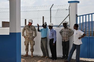
John Mietus is talking with the contractors.  Overall these guys did an awesome job.   It looks great and everything John asked them to fix, they did.


John is under the solar panels checking the  rating and wiring installation. 


 Here are the battery boxes and main breakers for the clinic.  Anywhere but the large cities rely on solar power or diesel generators.  They use large deep cycle batteries and an inverter to supply power to the lights, fans, and minimum loads of the clinic.  These systems seem to work well here, and are part of almost every contract. 

Monday, December 6, 2010

Another Week of Driving Djibouti

This past week I had two trips throughout Djibouti, one was taking a Major from AFRICOM around to sites for a tour and the second was a final inspection is Guistir. 
The first trip was a run around the southern half of the country.  The first stop was Kontali, where the SEABEEs are building a school building.  This only required a short stint offroading and was not too hot or windy.  

Here is a picture of the school being built.  It’s a basic concrete structure with three classrooms. 


This is one of the workers from the town working with the SEABEEs doing stucco application.  It’s always good to see the town assisting on these projects, even though it is a requirement. 


This is the town of Kontali as seen from the veranda of the school.   Unfortunately this town was so small that I could not locate it on Google Maps, so no coordinates.


The next stop was Dikhil, for an addition to the medical clinic.  As we wandered around the site, we saw this goat with its kid.  We found out that it had been born on hours before, I had to take a picture.
 
 
This is one of the buildings, which is to hold the x-ray room.  The acquiring of the lead lining for the room, and its installation is holding everything up.   The guy in the shot is Abdi, one of our translators.  He is a great guy, helping us out both with the language and culture, especially hooking us up with the local merchants.


Here is the building of examination rooms.  The town really needs this building opened up, there was a line at the older building of people needing to be seen.


On our way back to Djibouti City, we saw this truck on the road.  They get all the camels to lay down, but their necks stick up.  As the truck enters a turn, all of the camel’s necks are swung outboard.  It was fun to watch, but the truck stinks something awful. 


We stopped for lunch in Ali Sabieh, which was a small detour, this was the writing on the side of the mountain next to the restaurant.  The GPS location was:   11.153635  42.713503


This is our lunch.  They are known at the base for their excellent spicy spaghetti, using local peppers.  One of the guys said it was camel meat in the sauce, but Abdi clarified that it was just local ground beef.  And I was really hopeful that it was camel, I have never eaten it before. 


On the way out of the town, Abdi told us that back in WW II, the Italians dug out the hillside and put in these pill boxes to defend against people crossing through this important pass.  The entrance was on the back side of the mountain.


These are just some close-ups of the openings.  The tunnel must run for at least two miles connecting all of these.


Another treat on the way back was a bunch of baboons.  Since we had that Major from AFRICOM with us, we decided to stop.  This was a much larger group then any of us have ever seen.  We threw some food out for them.  This was the Alpha male inspecting us before we put food into the equation, then he really liked us.


I had to take a picture of his red butt, it was just too funny.


The male was hogging all of the food, grabbing it and then sitting on it.  This young one got brave, snuck up, reached underneath, and was rewarded, before being bobbed on the head.


Our last stop was Ecole 5, a school that a local Djiboutian contractor started, but was released due to poor quality.  The US Navy SEABEEs then took on the rest of the project and have been working really hard to finish the mess that was left for them.  This is the back wall of the school, with a forest of 2x4s holding up the forms for the roof beams. 

The front of the forms looked really good.  There was still a massive amount of rebar work and forms before they would be ready for the pour. 

French Beach Liberty Trip

   On Sunday, 28 November, I went out on Liberty with a couple of guys.  We left base and went into downtown Djibouti to Menelik Square, which is the small tourist/shopping district.  After circling for a bit, we found a parking space and walked back to the square.  We ran into some other people we knew from base, and they had a guy that spoke French, plus some Arabic, with them.  We hung out with them, first going to a small café and having some coffee and crepes. 
    We wandered the tourist shops and I bought some more ‘Africrap’.  I can’t say what, because it was sent home as a present to my wife.  Bartering with the vendors was fun and I got some good stuff.  We then wandered down to the French market, but wasn’t that impressed.  We then turned back west and headed toward the French Beach.  Some people have asked for some idea of where these places are that I am going, so from now on I will provide the Google Maps GPS coordinates for them.  You should be able to copy the numbers and paste it directly into the search window of Google Maps and pull up the location. 
   The GPS numbers for French Beach are:  11.592956 43.020229
  The beach was very nice, but had a somewhat difficult offroad trail to get there.  I never had to put the Land Cruiser into 4x4 mode, it plowed through just fine.  My riders were not as confident, and were gripping the handles with white knuckles.  This trail was nowhere near as bad as stuff I hit in the Sierras or Monterey.  Once we were at the beach, it was quiet nice.


Here is a shot of a camel on the road down there, it had to be the oldest one I have seen so far.  It was old enough to have lost the majority of it hair.


This is a shot of the covered seating areas that are available.  It costs about $2.50 per person to sit under them for the afternoon, plus a Djiboutian ‘watches’ your vehicle…. I didn’t sweat the money.  I put my stuff down, assembled my underwater camera, unpacked my snorkel gear, and headed for the water.  My cohorts just sat back in the breeze and enjoyed the view. 


I went snorkeling off the beach, which stayed shallow and full of a type of seagrass I had never seen before.  I finally started hitting some corals, and then the reef formed up and dropped off into deep water.  This is one of the many pieces of health coral that were down there. 


Unfortunately the visibility wasn’t as good as I had hoped, and doing underwater photography while snorkeling is much harder than when I am actually diving.  Here is a shot of an Indian Ocean relative to the Rock Beauty, a type of angelfish. 

I was enjoying diving is something other than the Atlantic or cold Pacific, allowing me to see my first Lionfish.


The juvenile fish here were even more brightly colored than I am used to in the FL Keys.  Here is a young angelfish next to a sponge. 
Though I took MANY other shots, the cloudiness of the water meant that the strobe just lit up a particle in front of the lens and not my main subject.  I hope to have better luck when the water isn’t like soup.


Tuesday, November 23, 2010

Lac Assal Liberty Trip


I took my first liberty trip with 3 other inmates of Camp Lemonnier out to Lac Assal.  This lake is the highest salinity lake anywhere except Antartica, and lies roughly 509 feet below sea level.  It is about 100km due west of the base, with the vast majority of the roads being paved.  We stopped at some overlooks on the way out, but unfortunately my camera was on the wrong setting and those pictures did not come out, darn, I guess I will have to take liberty out there again.  But at these stops Djiboutians were selling a variety of items of which I bought some.  I would take pictures of them or describe them, but they are surprises for my wife. 


This is a shot from the road to the west across the lake.  The mountains to get to the lake are at about 2200 ft and then we drive down and down until we are 500ft below sea level. 


This is looking from the spot where we pulled our truck over and explored.  The white salt flat is about 2 feet deep out to that island.  The island is made of almost completely of salt.  The crystals stained the color of the earth.


This is the civilian filling a water bottle with water from the lake.  The only way to describe it is syrupy.  The water actually feels thick with the salt.  After swimming, when you stood up in the hot breeze the water dried very quickly and salt crystals formed on skin, body hair, ears, and clothes.  Shorts became stiff with a solid white layer of salt. 


This is a close-up shot of the salt crystals along the short.  The small cubes that you see are about 1/8 inch on a side.  They are growing all around the entire edge of the lake and on anything in the lake like sticks and rocks.  It looks fragile, but it is actually quite strong.  The entire bottom of this bay was similar, but much sharper.  Two others from the group put their hand down and it instantly sliced through their hands and feet.  Then the excruciating pain would set in from the hyper-saline solution and the burning that lasted the rest of the day. 


This is a shot of the deeper water.  The civilian and I walked out to the deep water and jumped in, though there were main waves, we floated upright like corks.  To give you an idea of how buoyant being in this water was, getting my teva sandal underwater was difficult.  To actually get vertical, I had to bring my knees to my chest and thrust them downwards before the wanted to go up to the surface. 


Here is another liberty group from Camp further to the east.  You can see the prior salt marks on the mountain behind them. 


On the way back to Camp we were able to see some good wildlife.  Here are a couple Antelope, which unfortunately ran before I could get stable and get some good shots, plus in the small canyon we were in , the wild was howling and I couldn’t stabilize the lens at all. 


In Africa are the Acacia trees, which have wickedly sharp 1.5 inch thorns.  The goats and camels love the leaves and often work against those thorns to get at the leaves.  These goats solved the problem by climbing on top of this tree and eat downwards instead of straining upwards from the ground.  These was just one group, there were probably 2 dozen of these goats in the trees in this area alone. 


The last of the cool animals this trip was a baboon.  They are normally not out in the heat of the day, rather I have only seen them on my early morning excursions to nearby towns.  This large male was out and about and ran out in front of us.  We all acted like idiots making noises to try to get it closer, kinda wish I had a video of us acting like morons calling it. 
 It was a great trip and can’t wait to get out there again.  I have other liberty trips planned in the upcoming weeks, including whale shark snorkeling and a dive trip, which I will fully employ the underwater camera I have.

Monday, November 15, 2010

Cheetah Preserve and Other Trips


These past 4 days have been very busy.  On Thursday, the morning started early with a run out to Chabelley to oversee more concrete pours.  This was supposed to be a day off for Veterans Day, but we had to go out and supervise this evolution since Djibouti doesn’t exactly stop work for US holidays.  This also meant that we couldn’t get a couple of SeaBees to help us out.  Unfortunately my fellow ED wasn’t feeling well, so he set down in a chair to watch the concrete mixing and I ran around directing the pouring and wetting the concrete as it baked in the African sun. 


As you can see the forms for the columns on the completed slabs were being erected.  One of them fell in the high winds and just barely missed LT Mietus. 

The afternoon was spent driving around Djibouti dropping of some equipment and our translator.  Driving in downtown Djibouti is a special experience… where road rage is a state of mind that must be maintained to fit into traffic.  I got back onto base and quickly closed out the mission so I could get onto the bus out to the Cheetah Preserve.  The trip was supposed to be from 1600-1800, but we didn’t leave base until 1635 and didn’t arrive until just shy of 1700.  That gave us only 35 minutes of daylight.  I ran around and tried to get pictures of what animals I could.  The MWR trip was so limited, so I am trying to get out there on another Sunday with LT Mietus since he speaks French and can act as a tour guide.  


A couple of shots of the cheetahs.  I didn’t know that we were actually allowed into their cage, cause I wandered off on a hiking trail.  When I got back the MWR group was in the cage.  I missed out on that, but I will get back there and get some close-up shots without the fence.

Here is a young antelope in a pen.  There were a handful of very young ones in a penned off area.  I have seen them on my drives around recently in the wild.

Here is a tortoise, they didn’t need a fence to hold them, just closely spaced rocks kept them contained.
Unfortunately due to the setting sun, I didn’t have good light for the rest of the shots.